


WWW.LIVESCIENCE.COM
Colossal scars of 60 million-year-long continental collision streak across warped mountains in Pakistan Earth from space
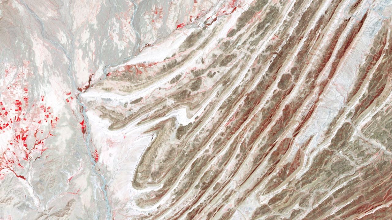
QUICK FACTSWhere is it? Murgha Kibzai, Sulaiman Range, Pakistan [30.739354851, 69.50804296]What's in the photo? Folded layers of rock left over from an ancient continental collisionWhich satellite took the photo? NASA's Terra satelliteWhen was it taken? April 11, 2011This striking satellite photo shows a multicolor "fan" of folded rocks sculpted by a longtime collision between two of Earth's tectonic plates.The geological feature, known as an imbricate fan, is located around 3 miles (5 kilometers) east of the town of Murgha Kibzai in Pakistan's Balochistan province. The photographed section of folded rocks measures around 9 miles (15 km) across, but the fan stretches up to 55 miles (89 km) from end to end, well beyond the area in this image. The dramatic structure sits at an altitude of around 5,000 feet (1,500 meters) in the Sulaiman Range, a series of mountains that covers around 2,500 square miles (6,500 square kilometers) of Pakistan and Afghanistan. ("Sulaiman" means "of Solomon," in reference to the biblical figure King Solomon, and the range's largest peak is Takht-e-Sulaiman, which translates to "Throne of Solomon.")This is one of several unique features that emerged along the boundary between the Eurasian and Indian tectonic plates, which have been colliding for more than 60 million years. At one point during this tectonic tug-of-war, the two plates became somewhat intertwined, allowing the fan to take shape, according to NASA's Earth Observatory."As India moved northward, it began to rotate in a counter-clockwise direction, wrenching the northwestern part of the Indian plate backwards into part of the Eurasian plate," Earth Observatory representatives wrote. "The countervailing forces put the rocks of the Sulaiman Range in a unique compressional vice, causing many of its faults to curve and stretch in convoluted ways."The Sulaiman Range is full of unique geological features that were birthed by the collision between the Indian and Eurasian plates. (The imbricate fan is located on the far right of this wide-field image.) (Image credit: NASA/Terra)The fan is made up of alternating layers of sandstone, which appear dark in the image, and limestone, which has a much lighter hue. These sedimentary rocks were formed by "thrust faults" that shot upward from the boundary between the Eurasian and Indian plates and became entangled as the boundary moved back and forth.The satellite image is false-color, meaning it includes wavelengths of the electromagnetic spectrum that are not normally visible to humans. This helps to accentuate the differences between the two rock types, although they can also be easily distinguished with the naked eye. Pockets of vegetation appear in red throughout the image.The photo is a small part of a larger, wide-field image (see above), which showcases several other intriguing geological features across the Sulaiman Range in false color. Continental collisionThe collision between the Eurasian and Indian plates became inevitable around 80 million years ago, when dinosaurs still ruled Earth, according to the Earth Observatory. At this point, the pair became locked on a collision course, with each plate moving more than 8 inches (20 centimeters) per year around twice the speed of the fastest tectonic plates today.Around 60 million years ago, the plates slowly slammed together. Normally, this would cause the smallest tectonic plate to sink below the other. However, the two plates' massive size meant neither receded. Instead, the continental crust along the boundary grew thicker, and the ground buckled, folded and pushed upward. The Indian and Eurasian plates have been locked in a tectonic tug-of-war for more than 60 million years. Their collision birthed the Sulaiman Range, alongside the Karakoram and the Himalayas. (Image credit: Getty Images)This process created not only the Sulaiman Range but also the Karakoram (a huge mountain range that spans the borders of China, India, Pakistan, Tajikistan and Afghanistan) and the Himalayas the two tallest mountain ranges on Earth, according to the Earth Observatory.This collision continued at full speed for around 30 million years, before eventually slowing down. However, the two plates are still technically colliding today, making the region a major earthquake hotspot. See more Earth from space Shadowy tendrils of lava A 2019 astronaut photo shows off ancient lava flows that once oozed down the jet-black slopes of the Toussid volcano in northwestern Chad. An intriguing volcanic "skull" also lurks in the aerial image. Volcanic 'Twin peaks' A 2021 astronaut photo shows the surprising similarities between Mount Sundoro and Mount Sumbing, which lie at the heart of Java, Indonesia. Concentric rocky rings A 2025 astronaut photo shows a massif made of concentric mountain ridges in the Libyan desert. The rocky walls contain ancient artworks and are occasionally used to contain herds of grazing cattle.
0 Комментарии
0 Поделились
23 Просмотры

 English
 Arabic
 French
 Spanish
 Portuguese
 Deutsch
 Turkish
 Dutch
Dutch
 Italiano
 Romaian
 Portuguese (Brazil)
 Greek
Greek