ALLTHATSINTERESTING.COM
The Disturbing Story Of Larry Hall, The Civil War Buff Who May Have Killed 40 Women
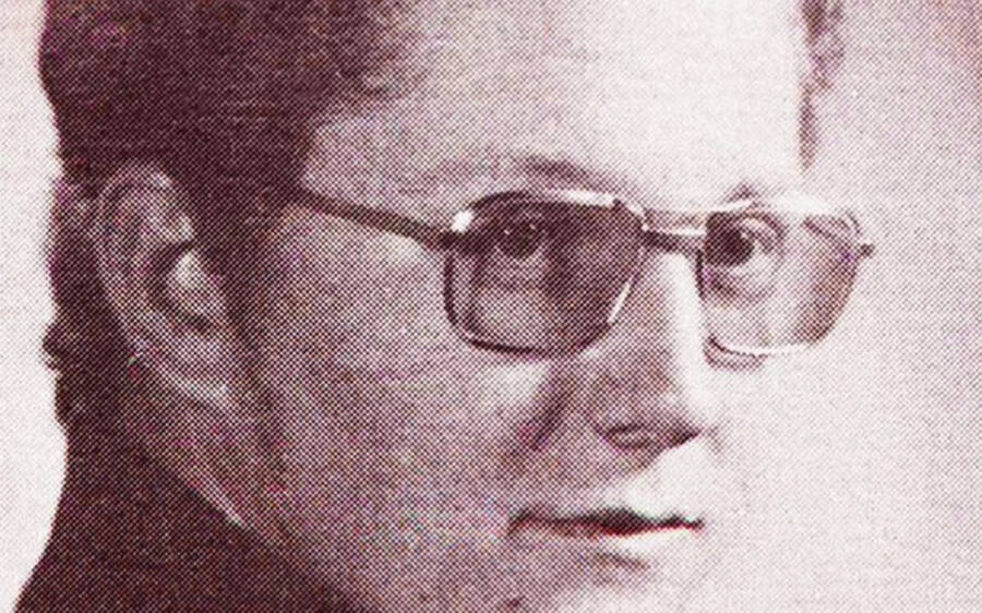
The true crime miniseries Black Bird follows James Jimmy Keene as he goes undercover to extract a confession from suspected serial killer Larry Hall. The show is based on Keenes 2010 memoir, In with the Devil, which recounts his very real experience with Hall, a man who may be responsible for more than 40 murders.But just who is Larry Hall?Unlike other serial killers like Ted Bundy and Jeffrey Dahmer, the exact details of Halls life and crimes havent been widely publicized despite the fact that he may be one of the most prolific serial killers in American history.Wikimedia CommonsLarry Halls 1994 mugshot.Although Hall admitted to killing dozens of women and girls throughout the 1980s and 90s, he immediately recanted his confession. He was sentenced to life in prison for kidnapping a 15-year-old in 1993, but he was never charged with her murder or the murders of any of his other potential victims.Still, the details about Larry Halls life that have been made public paint a picture of a highly disturbed man capable of committing some of the most heinous acts imaginable. This is his story.The Troubled Childhood Of Larry HallLarry Dewayne Hall and his twin brother Gary were born on Dec. 11, 1962, in Wabash, Indiana. The two boys were monochorionic twins, meaning they shared a placenta. Unfortunately for Larry, his brother received the majority of the nutrients and oxygen in the womb, so newborn Larry was rushed to the neonatal intensive care unit soon after he was born.Because of the medical issues surrounding his development and birth, Larry Hall suffered from cognitive delays. His peers made fun of him for his speech impediment and the fact that he wet his bed well into childhood.Additionally, as Gary Hall recalled to CNN in 2011, Larry was awkward growing up and showed signs of destructive behavior. He was the backward twin. I was the more dominant, outgoing twin, Gary said. He claimed that he tried to be a good influence on his brother, but to no avail. According to Gary, Larry was evil and even tried to kill him on more than one occasion.Once, Gary recalled, I just woke up out of a sound sleep to see my brother standin over me with this humongous long limb, getting ready to smash my skull.Larry Halls first brush with the law came when he was 15, when he and Gary were caught breaking the windows of a store. One of the police officers who questioned them after the incident later recalled, It took a long time before we could crack the Hall brothers. They were just kids, but they held up better than hardened criminals.It wouldnt be the last time Larry Hall baffled investigators.Inside Larry Halls Alleged Killing SpreeAfter high school, Larry Hall began traveling across the Midwest to participate in Civil War reenactments. Oddly, it seemed that girls and young women would go missing in each town that Hall visited.Its not clear who Halls first victim was, but in June 1982, 19-year-old Naomi Kidder went missing in Wyoming. When police eventually arrested Hall for other crimes 12 years later, they found a document with Kidders name on it among his possessions. But the case that finally put Larry Hall on investigators radar was the disappearance of a 15-year-old girl named Jessica Roach from Georgetown, Illinois, in September 1993. She was last seen riding her bicycle near her home. Two months later, her body was discovered in an Indiana cornfield. Witnesses had seen a strange van driving through the cornfield around the time Roachs body was found and police traced the license plate number back to Hall. Whats more, another teenager named Tricia Lynn Reitler had vanished in Indiana six months prior to Roachs disappearance, and the girls cases were oddly similar.Family of Tricia ReitlerTricia Reitler, circa 1993. To this day, her family is unsure of what happened to her.On March 29, 1993, 19-year-old Reitler had been in the middle of writing a term paper when she decided to take a break. She left her dorm and went to a store just half a mile away to pick up a soda and a magazine.She never returned to her room.Instead, police believe Reitler was abducted during her walk back. Her parents think she was killed that very night, but her body has never been found. Hall had reportedly been seen stalking women outside the store where Reitler was shopping.Now that investigators had evidence connecting Larry Hall to the scene of at least one of the mysterious disappearances, they brought him in for questioning and they were stunned by what they heard.His Disturbing ConfessionsInvestigators had never heard of Larry Hall before linking his vehicle to Jessica Roachs disappearance. But as soon as they brought him in, it was obvious that he knew something. Gary Miller, the chief investigator for the Vermilion County Sheriffs Office in Illinois, brought Hall into the police station for questioning and showed him a picture of Jessica. He immediately flinched. He turned to his right and put his hand up over his face like he didnt want to see the picture. And he told me he didnt think hed ever seen that girl, Miller recalled to CNN. It didnt take long for Hall to confess. He admitted to investigators that he had raped Jessica and strangled her in the woods. I laid her up against a tree and put a belt around her neck and she stopped breathing, Hall said. FacebookJessica Roach, the young girl who Larry Hall confessed to kidnapping and killing before recanting his statement.Hall also admitted to hurting other girls including Reitler, whom he identified by pointing to her picture. All of the girls looked alike, Hall said. I cannot remember all of them. I picked up several girls in other areas, but I cant remember which ones I hurt.But the very next day, Larry Hall recanted everything. He reportedly told Miller, I was just tellin you about my dreams. That didnt really happen. Unfortunately, Hall would continue to confess and immediately recant whenever he was questioned. Investigators had a difficult time nailing down a confession from Hall that he would not later withdraw. They decided that they needed someone on the inside who could obtain a real admission from him. They found their man in Jimmy Keene. Jimmy Keenes Attempt To Take Down Larry HallIn 1995, Larry Hall was found guilty of kidnapping Jessica Roach and sentenced to life in prison, but there were still many questions left unanswered. How many girls had Larry Hall actually killed? Was he truly the man responsible for Tricia Reitlers disappearance? And if so, where was her body?Meanwhile, a man named Jimmy Keene was serving 10 years in prison on a drug charge. Both Hall and Keene had been prosecuted by Lawrence Beaumont, who was determined to discover the true extent of Halls crimes. Just 10 months into Keenes sentence, Beaumont approached him to work out a deal: If he would go undercover as an FBI operative and get a confession from Larry Hall, he would be freed and his record would be scrubbed clean. Naturally, Keene accepted and was transferred to the Springfield, Missouri, prison where Hall was incarcerated. There, Keene befriended Hall and set to work gaining his trust.At one point, Keene observed Hall in the prison wood shop, carving falcons and looking over a map that hed marked up. According to Newsweek, Keene said that Hall told him the falcons watch over the dead, leading Keene to believe the marked locations were the spots where Hall had killed his suspected victims.Apple/XActor Taron Egerton (left), who portrays Jimmy Keene in Black Bird, on set with the real Jimmy Keene (right).Keene felt he had solved the case. He called the FBI and left them a message about the map. Believing that he would soon be pulled out of prison, Keene angrily confronted Hall about the alleged killings and got himself sent to solitary confinement. Unfortunately for Keene, the FBI never got his message. He spent weeks in confinement, and when he was released, Hall had discarded the map and the falcons. Keene was freed, but Halls alleged crimes went unpunished once more.Ultimately, no one is entirely certain how many murders Larry Hall is actually responsible for other than Hall himself.After learning about Larry Hall and his numerous suspected killings, learn about the gruesome crimes of Jason Alan Thornburg, the Texas serial killer suspected of making biblical sacrifices. Then, discover the story of Wayne Nance, the suspected serial killer who terrorized Montana.The post The Disturbing Story Of Larry Hall, The Civil War Buff Who May Have Killed 40 Women appeared first on All That's Interesting.
0 Reacties
0 aandelen
218 Views