

Path Of Hurricane Erin, One Of The Fastest-Strengthening Storms On Record, Captured In Dramatic Satellite Images
Path Of Hurricane Erin, One Of The Fastest-Strengthening Storms On Record, Captured In Dramatic Satellite Images
Hurricane Erin, the first of the 2025 season, has been raging off the coast of the Caribbean and the US Eastern Seaboard this last week. Thankfully it did not make landfall, because this storm rapidly transformed from a tropical storm to a Category 5 hurricane in little over a day, producing heavy rains and rip currents that affected coastal areas in the Caribbean.
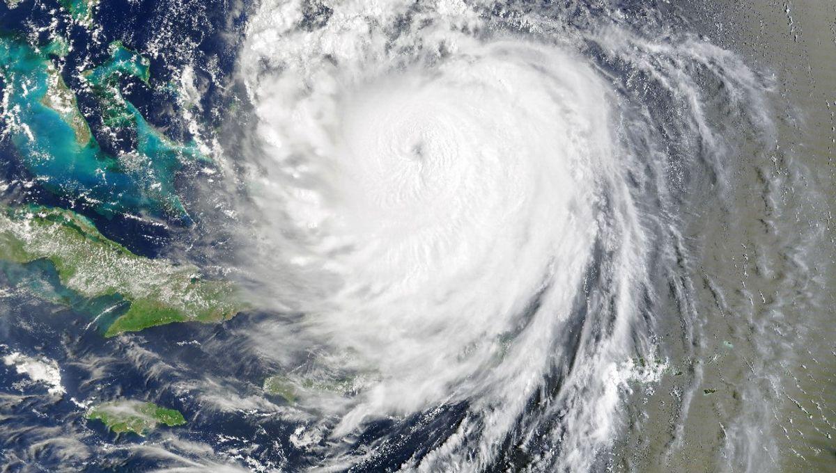
The rest of this article is behind a paywall. Please sign in or subscribe to access the full content. The Atlantic storm was first deemed to have reached hurricane strength on August 15. Only a day later, as it progressed towards the Caribbean and East Coast of the USA, it had intensified into a Category 5 hurricane. This incredible development was captured by satellite images shared by NASA Earth Observatory. According to this imagery, the storm reached its strongest wind speeds – 160 miles (260 kilometers) per hour – on August 16, as it reached just north of Puerto Rico. Hurricane Erin started its life as a tropical storm in the Atlantic but transformed into a Category 5 hurricane within a day of being deemed as "hurricane strength". Image credit: NASA Earth Observatory/Michala Garrison, using MODIS data from NASA EOSDIS LANCE and GIBS/Worldview, and the Suomi National Polar-orbiting Partnership Erin’s rapid ascent to its monstrous statusmakes it one of the Atlantic’s fastest-strengthening storms on record, according to the National Environmental Satellite, Data, and Information Service. It is also the earliest storm of this strength ever recorded in this part of the Atlantic. It was able to reach this strength due to a few factors. Firstly, its own compact size and its relatively lighter light wind shear – the variation of wind velocity over horizontal or vertical distances – allowed it to strengthen quickly, and it took advantage of the unusually warm sea surface temperature that occurred this month too. After this, Erin gradually moved westwards, where it weakened slightly, due to what’s referred to as eyewall replacement cycles. This process sees intense hurricanes develop a new eye, and although this tends to decrease wind speeds, it does expand the size of the wind field. Although it did not reach the Caribbean islands, its outer bands did strike them as it passed. This brought heavy rain and high winds to Puerto Rico and knocked out local power. The storm then turned northwards and ran parallel to the US East Coast as it weakened to a Category 2 storm. Erin's rapid intensification is a worrying example of a phenomenon that is becoming more common as human-caused climate change continues. In fact, Erin is just the latest example of a Category 5 hurricane in a growing string of similar storms. As Ian Livingston from The Washington Post points out, there have only been 33 seasons with Category 5 storms since 1924. That might not sound like a lot, but the time between seasons with such strong hurricanes has been rapidly decreasing. Prior to the last decade, which has seen 11 Category 5s, it took 27 years for the previous 11 Category 5 storms to occur, and 34 years for the 11 preceding those. Hurricanes are now becoming so strong that some scientists believe we need a new category to capture their power – a Category 6. However, cuts to American research have left some questioning whether we will have the ability to track and prepare for these increasingly dangerous storms. Although hurricane categorization is based on their maximum sustained wind speed (the Saffir-Simpson Hurricane Wind Scale), it is not necessarily the storm’s winds that directly claim lives. The most dangerous part is actually the storm surge and flooding, which cause the most fatalities, especially along coastal areas. It was the massive storm surge created by Hurricane Katrina in 2005, for example, that led to the widespread flooding and deaths. Erin may be the first storm of the season to reach such strengths, but it likely will not be the last we see this year. .gif "A gif showing the satellite images of Hurricane Erin progressing from the Atlantic towards the Caribbean islands. The storm becomes larger as it moves and then swoops northwards before making landfall. At the bottom of the image, there are dates extending from August 14 to August 19.")