



On a sweltering morning somewhere along the middle Euphrates, a farmer hauls water from a river that has been doing exactly this — feeding crops, sustaining lives, building civilizations — for longer than writing itself has existed. He probably calls it the Furat, the Arabic name his ancestors have used for centuries. He almost certainly does not call it Mesopotamian. And yet, in every practical sense, that is precisely what it is.
A Civilization Built on Two Rivers That Still Flow

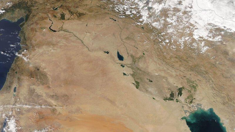
The paradox at the heart of Mesopotamia is this: the name has vanished from every political map on Earth, yet the physical reality it described — two rivers, a floodplain, a ribbon of impossible fertility cutting through an otherwise punishing landscape — is stubbornly, quietly still there. You can find it on satellite imagery. You can drive to it. You can drink from it.
When scholars working in the wake of Alexander the Great’s conquests popularized the term Mesopotamia, they reached for Greek with the precision of scientists naming a species. Mesos plus potamos: between rivers. It was a geographic description before it was a historical label, and that geographic description remains accurate to this day. The rivers are still there. The silt they carry is still some of the richest agricultural soil on the planet. What changed is everything layered on top of them — the empires, the city-states, the very concept of civilization as humans first invented it, and finally the name itself.
So where, exactly, was Mesopotamia? Which countries now stand on that ancient ground? And what happened to those two legendary rivers in the millennia since Babylon fell? The answers are more alive — and more urgent — than most people expect.
Drawing the Map: What Ancient Mesopotamia’s Geography Actually Looked Like

Anchor yourself to a mental map of West Asia. Draw a rough crescent shape curving from the eastern Mediterranean coast up through what is now Syria and Turkey, then swooping south through modern Iraq toward the Persian Gulf. That arc is the Fertile Crescent — the broad sweep of productive land that cradled the earliest experiments in settled human life. Mesopotamia occupied the northern part of the Fertile Crescent, the section watered most generously by those two rivers, and in terms of sheer agricultural productivity it was the crescent’s crown jewel.
The region divided naturally into two very different personalities. Upper Mesopotamia spread across the rolling, rain-fed hills of the north — the territory that corresponds today to southeastern Turkey and northeastern Syria. Here, farmers could grow wheat without elaborate irrigation systems, watered by seasonal rains. Cities and trading villages dotted the upper Euphrates and Tigris valleys, prosperous but not yet the thunderous urban giants that would define the region’s reputation.
Lower Mesopotamia was something else entirely. Flat, broiling, and almost rainless, it stretched across the vast alluvial plain that is essentially modern Iraq — a landscape that should, by any reasonable measure, have been too harsh to support dense civilization. What made it extraordinary was what the rivers brought: an annual flood that deposited layer after layer of fabulously rich silt across the plain, creating soil capable of producing grain yields that stunned ancient observers. Without irrigation, it was desert. With it, it was among the most productive farmland on Earth.
The borders of this world were drawn by geography as much as by politics. To the west, the Syrian Desert formed a nearly impassable barrier of stone and sand. To the east, the Zagros Mountains rose like a fortress wall separating the plains from the Iranian plateau. To the north, the Taurus range capped the system. Everything inside those natural walls funneled down toward the rivers. The Tigris and Euphrates were not merely water sources. They were the civilization’s entire circulatory system — simultaneously the reason cities could exist here and the force that periodically obliterated everything humans had built along their banks.
The Tigris and the Euphrates: Two Rivers, Two Very Different Personalities

If you had to describe the Euphrates in a single word, that word might be generous. Longer and slower than its companion — winding roughly 1,740 miles from the highlands of eastern Turkey down through Syria and Iraq before draining into the Persian Gulf — the Euphrates moved with a relative predictability that ancient city planners could work with. Its floods, while powerful, followed a seasonal rhythm that farmers learned to read and trust. Babylon, Nippur, and Ur all clustered near its banks, drawing their lifeblood from its water and their building material from its clay.
The Tigris was a different creature altogether. Faster, fiercer, and prone to sudden and catastrophic flooding that could erase a settlement with minimal warning, it ran roughly parallel to the Euphrates but pressed closer to the Zagros Mountains. Where the Euphrates nurtured, the Tigris tested. The cities that rose on its banks — Nineveh, Ashur, and later Baghdad — tended to become military and administrative capitals more than the religious and agricultural centers that clustered on the Euphrates to the west.
In antiquity, the two rivers did not rush together the way modern maps might suggest. The land between them was broader, more distinct, and the delta region far more separated than today’s merged waterway — the Shatt al-Arab — implies. Millennia of sedimentation and human engineering have pushed the rivers’ confluence point steadily northward, contracting what was once a much wider expanse of river-threaded marshland into the more compressed delta we see today.
Along these two watercourses, in the stretch of land between them and on their banks, rose every civilization that made the ancient Near East the cradle of recorded human history: Sumer, Akkad, Babylon, and Assyria — each one layering its ruins onto the ruins of predecessors, creating the archaeological stratigraphy that still keeps excavators busy today. The Tigris-Euphrates river system is, without much serious competition, the most consequential river duo in all of recorded history.
Where Is Mesopotamia Today? The Modern Countries That Inherited Ancient Ground

The answer to “where is Mesopotamia today” can be stated directly: the region that ancient sources called Mesopotamia is now divided among modern-day Iraq, Syria, Turkey, and Kuwait — with Iraq holding by far the largest share and the most immediate geographic and cultural claim to that inheritance.
Iraq is the heartland. Present-day Baghdad sits along the Tigris near the zone where ancient powers staged their successive bids for regional dominance. Drive roughly 55 miles south of the capital and you reach Babylon — or what remains of it, the old baked-brick ruins rising from the plain beside the Euphrates. Continue south toward Basra and you reach the great marshes, the same reed-threaded wetlands that Sumerian communities navigated by boat thousands of years ago. Modern Iraq sits at the geographic and historical center of ancient Mesopotamia, a fact that gives the country’s long, troubled modern history an almost unbearable weight of irony.
Syria holds a significant slice of the northwestern story. Northeastern Syria — particularly the region around Deir ez-Zor and the upper Euphrates valley — was the heartland of Upper Mesopotamia, home to trading cities and farming communities that supplied grain and goods to the urban giants of the south. The suffering that northeastern Syria has endured in recent decades has made it difficult for outsiders to remember that this territory was once one of the most economically productive corridors in the ancient world.
Turkey and Kuwait occupy Mesopotamia’s outer edges. Southeastern Turkey — the uplands near modern Diyarbakır, where the Tigris and Euphrates gather their early strength from mountain snowmelt — was the northern shoulder of the Mesopotamian world, the zone where the rivers were born before they began their long journey south. Kuwait and the northern shore of the Persian Gulf formed the region’s southern fringe, where the rivers finally exhausted themselves into the sea and where ancient trade routes connected the alluvial plains to the wider maritime world of the Gulf and Indian Ocean.
The Fertile Crescent Context: Why Location Was Everything

Zoom far enough out and the reason Mesopotamia mattered becomes almost embarrassingly obvious. Situated at the richest, most flood-watered section of the Fertile Crescent, the land between the rivers was essentially the only place in the ancient Near East where you could reliably grow enough food to support cities — not villages, not towns, but actual cities of tens of thousands of people, with professional administrators, specialized craftspeople, standing armies, and the crushing logistical complexity that forces humans to invent new tools of organization.
Everything surrounding Mesopotamia pushed people toward it. The Arabian Desert sprawled to the southwest. The Anatolian plateau rose to the north. The Iranian highlands pressed from the east. Peoples from every direction were drawn toward the rivers, and that constant pressure of migration, trade, and conquest is precisely why so many civilizations layered themselves on top of each other across the same geography for so many millennia. Mesopotamia was not just an address. It was a forcing function for human history.
The resulting complexity drove invention at a pace the ancient world had never seen. Writing — cuneiform script, pressed into clay tablets from around 3100 BCE — emerged here because irrigated agriculture created surpluses large enough to require accounting, and accounting at scale demands a recording system. Mesopotamian astronomers and mathematicians developed sophisticated systems for tracking celestial cycles, work that influenced later divisions of time and angular measurement. The earliest surviving law code of substantial length, associated with the Babylonian king Hammurabi and dated to around 1754 BCE, emerged from a society complex enough to need written law simply to function. All of it came from this specific patch of what we now call the modern Middle East — a geographic fact that becomes quietly astonishing when you overlay contemporary news maps with five-thousand-year-old city names and realize how many of the datelines are the same.
What Happened to the Rivers — and the Land — Since Then

The Tigris and Euphrates of today are not the rivers that Hammurabi knew. They are diminished, redirected, dammed, drained, and under pressure that their ancient banks never had to bear.
Turkey’s dam-building programs across the twentieth century transformed the upper reaches of both rivers. The Atatürk Dam on the Euphrates, completed in 1992, dramatically reduced the water that flows downstream into Syria and Iraq — a source of geopolitical friction that has only intensified as climate-driven drought tightens its grip on the entire region. Iraq has built its own dams. Iran has redirected tributaries of the Tigris. The combined effect has been a measurable decline in both rivers’ flow at their lower reaches, threatening the agriculture and drinking water of millions of people living on the same alluvial plain that sustained ancient Sumer.
The soil itself carries a historical wound. Centuries of irrigation without adequate drainage loaded Lower Mesopotamian farmland with salt — a slow, invisible salinization that archaeologists believe contributed to Sumer’s gradual agricultural decline after 2000 BCE. Farmers noticed that wheat crops began to fail and that only salt-tolerant barley would grow where rich grain had once flourished. That same crisis, in updated form, is still playing out in southern Iraq today, where saline soils reduce crop yields and force farmers off land their families have worked for generations.
Perhaps the most dramatic ecological story of the modern era involves the southern marshes. These vast, reed-threaded wetlands — almost certainly the landscape that shaped ancient Sumerian myths about the world emerging from primordial water — were deliberately drained by Saddam Hussein’s government in the 1990s as punishment for Marsh Arab communities that had resisted his regime. In under a decade, a wetland ecosystem that had persisted for millennia was reduced to cracked, salt-crusted desert. After 2003, water was returned and the marshes began a slow recovery. In 2016, the Mesopotamian Marshes were designated a UNESCO World Heritage Site, recognized simultaneously as a natural wonder and a living cultural landscape. The Ma’dan — the Marsh Arabs who build their homes from bundled reeds, fish the shallow waterways, and orient their entire lives around the rhythms of water and bird migration — represent one of the most direct human threads connecting the present to the world’s earliest urban civilizations.
The Rivers Remember What the Maps Forgot
Return, finally, to that farmer at the Euphrates. He is working the same alluvial silt that built Babylon’s walls. He is fighting the same salinity that exhausted Sumer’s fields. He depends on the same seasonal pulse of water from the same mountain snowfields in Turkey that have been feeding these lowlands since before any human being thought to write anything down. He may not think of himself as Mesopotamian — that word belongs to history books and museum labels — but the land under his feet has never stopped being exactly what the Greeks named it: the place between the rivers.
The geographic answer, stated plainly: ancient Mesopotamia corresponds most closely to present-day Iraq at its center, with northeastern Syria, southeastern Turkey, and the northern edge of Kuwait forming its outer reaches. That is where the cities were. That is where writing was born. That is where the first monumental legal codes were carved and where astronomers mapped the night sky over that impossibly flat horizon.
The word Mesopotamia vanished from political maps centuries ago, erased by conquest and by the slow redrawing of the world that every empire undertakes. But the two rivers it was named for — the Tigris and the Euphrates — are still carving their ancient paths to the Gulf, still depositing silt, still flooding when the mountain snow melts, indifferent to every dynasty that has risen and crumbled on their banks. The land between the rivers is waiting, half-buried in silt, half-alive in the present, still recognizably itself after five thousand years of human ambition.

 English
 Arabic
 French
 Portuguese
 Deutsch
 Turkish
 Dutch
Dutch
 Italiano
 Russian
 Romaian
 Portuguese (Brazil)
 Greek
Greek