



Picture a young man — barefoot, lungs burning at 13,000 feet — sprinting along a stone-paved path that vanishes into an Andean cloud. He carries no letter, no map, no document of any kind. He carries a message in his memory and a knotted string in his fist, and when he reaches the next relay station a few miles down the mountain, he will hand both off to another runner who has been waiting, stretched and ready, for exactly this moment. In this way, word could travel from the imperial capital of Cusco to the northern city of Quito — a distance of roughly 1,200 miles of sheer Andean spine — in a matter of days. No horse. No wheel. No written word. Just the impossible, meticulous genius of the Inca.
The Central Paradox of the Inca Empire

The Inca Empire was the largest empire ever built in the pre-Columbian Americas, and it was constructed without three technologies that historians once considered basic prerequisites of empire-building at continental scale. No wheeled vehicles rolled along its roads. No horses carried its generals into battle or its messages across mountain passes. No alphabet or writing system recorded its laws, its histories, or its census data. And yet the Inca forged a realm that stretched, at its peak, approximately 4,000 miles from north to south — roughly the distance from the northern tip of Alaska to the southern border of Mexico — and governed an estimated 10 to 12 million people across some of the most extreme terrain on the planet.
What the Inca built was not a simpler version of the empires that came before it. It was something genuinely different: a civilization that solved the problems of scale, communication, and loyalty through human ingenuity rather than mechanical advantage. Understanding where the Inca Empire was — its geography, its mountains, its coasts, its roads — is the first step toward understanding how it functioned at all.
Where Was the Inca Empire? Mapping the Territory

Draw a line down the western edge of South America, following the spine of the Andes Mountains from the highlands of southern Colombia all the way to the Maule River in south-central Chile. That line, running roughly 4,000 miles through some of the highest and most rugged terrain on Earth, traces the skeleton of the Inca Empire — known in Quechua as Tawantinsuyu, meaning “the four regions together.”
At its fullest extent, the empire’s territory overlapped with what are now six modern nations: Peru as its undisputed heartland, along with Ecuador to the north, western and south-central Bolivia, northwest Argentina, and slivers of southern Colombia and northern Chile. It was not a tidy rectangle on a map — it was an organic shape carved by mountains, rivers, deserts, and the practical limits of Andean armies marching on foot.
The empire had two dramatic edges. To the west lay the Pacific Ocean coastline, backed by one of the driest deserts on Earth, the Atacama. Fishing communities and river-valley oases clung to life in narrow strips of habitable land between the ocean and the mountains — compact settlements that the Inca found relatively straightforward to incorporate into their tribute and labor system. To the east, the Andes collapsed into the green chaos of the Amazon basin, the cloud forests and jungle frontier the Inca called the ceja de selva — the eyebrow of the jungle. This was terrain the empire never fully conquered, a living boundary that marked the eastern limit of Tawantinsuyu.
At the center of this vast world sat Cusco, high in the Peruvian Andes at roughly 11,150 feet above sea level. The Inca did not merely think of Cusco as their capital. They called it Qusqu — the navel of the world — a sacred axis from which the four quarters of the empire radiated outward like the arms of a cross. Every road led back to it. Every tributary system flowed toward it. It was, in a very literal sense, the center of their universe.
The Size of the Inca Empire: Numbers in Context

At its peak, the Inca Empire covered approximately 770,000 square miles — a territory larger than the Roman Empire at several points in its own sprawling history, and larger than any empire to have existed in the pre-Columbian Western Hemisphere. It ran from the highlands near present-day southern Colombia to the Maule River in south-central Chile. Its subjects woke each morning at sea level on the Pacific coast, at the dizzying altitude of Lake Titicaca (12,500 feet, straddling the modern Peru-Bolivia border), and at every elevation in between.
That altitude variation was not incidental — it was, in a real sense, what made the empire possible. Scholars describe the Inca practice of “verticality” — the deliberate exploitation of different climate zones stacked along the mountain slopes. Potatoes, one of the Inca’s most important staple crops, could be grown at altitudes above 13,000 feet. Maize thrived in lower, warmer valleys. Coca leaves came from the cloud forests. Fish and shellfish arrived from the coast. By controlling the roads and storage systems that linked these zones, the Inca state could feed its people across an astonishing range of conditions, essentially turning the mountain landscape itself into a managed pantry.
Governing a territory this vast, across terrain this extreme, meant solving problems that no existing blueprint could address. How do you move food to an army marching through a desert? How do you count a population living in dozens of distinct ethnic groups, speaking dozens of languages, at altitudes that would incapacitate a lowland administrator? How do you hold the loyalty of a city 2,000 miles from your capital when a rebellion could take weeks to even reach your ears? The Inca answered every one of these questions. Their answers were strange, brilliant, and utterly their own.
Geography as Both Enemy and Ally

The Andes were not simply a backdrop to Inca civilization. They were its infrastructure — a natural system of corridors, climate zones, and defensible ridgelines that the Inca learned to read and exploit with extraordinary sophistication. Mountain passes that would stop wheeled vehicles became strategic arteries for Inca foot soldiers and llama caravans. River valleys that cut through the cordillera served as communication channels. The very difficulty of the terrain that made conquest so hard for outsiders became a home-field advantage for a civilization that had spent generations learning to live within it.
Lake Titicaca, shimmering at 12,500 feet on the border between modern Peru and Bolivia, held a special place in Inca geographic imagination. According to Inca belief, it was the birthplace of civilization itself — the place where the sun god Inti sent the first Inca, Manco Cápac, down to earth to found the kingdom that would become Tawantinsuyu. Geography and theology were therefore inseparable. To control the mountains and the lake was to hold the blessing of the sun itself.
The Pacific coastal desert, brutal as it was, also served the empire. Its aridity forced coastal populations to cluster in river-valley settlements — dense, predictable communities far easier to supply and govern than scattered highland villages. The Inca built roads through these desert corridors, connected the river-valley oases to the highland storage system, and incorporated fishing communities as specialized labor contributors within the broader state economy.
Only the eastern cloud forests consistently defeated Inca ambition. The ceja de selva — that green, precipitous tangle where the Andes fall away into the Amazon — was a frontier the empire probed repeatedly but never absorbed. Forest peoples resisted, the terrain resisted, and the climate resisted. The jungle became the permanent edge of the possible, a geographical limit that defined where Tawantinsuyu ended.
Running an Empire on Human Genius Alone

The road network alone would be remarkable by any era’s standards. The Qhapaq Ñan — the “Great Inca Road” — covered more than 25,000 miles of paved paths, stepped mountain switchbacks, and rope suspension bridges strung across Andean gorges. The entire system was built and maintained without wheeled vehicles or large draft animals, relying instead on the mit’a labor tax: the obligation of every subject to contribute a portion of their labor to the state each year. Workers built the roads. Workers maintained the bridges. Workers staffed thousands of roadside warehouses, called qollqas, that stored freeze-dried potatoes (chuño), dried meat, textiles, and weapons along every major route.
The Inca had no currency and no markets in the conventional sense. What they had was a system of reciprocal obligation: the state demanded labor, and in return the state fed, clothed, equipped, and ceremonially honored those who labored. It was a radically different economic logic from anything in the Mediterranean or European world — and it worked, at continental scale, across nearly a century of explosive territorial growth.
In place of writing, the Inca developed the quipu: a device of knotted and colored strings that encoded information through patterns of knot type, position, and color. Quipus recorded census data, tribute obligations, and possibly narrative histories. They were read by specialists called quipucamayocs — keepers of the knots — who formed a kind of civil service capable of transmitting and storing complex information across the empire without a single written character.
The empire’s official language, Quechua, was spread as a deliberate policy of cultural unification. Officials, priests, and soldiers carried it into newly conquered territories, creating a shared lingua franca across dozens of distinct ethnic groups. Today, roughly 8 to 10 million people across Peru, Bolivia, Ecuador, and beyond still speak Quechua — a linguistic survival that outlasted conquest, colonialism, and centuries of suppression.
Rise and Fall: A Century That Changed a Continent

Tawantinsuyu expanded from a small Andean kingdom into a continental power in less than a century, between roughly 1438 and 1533. The architect of that transformation was Pachacuti, the ninth Sapa Inca, who rebuilt Cusco as a royal capital, launched military campaigns that eventually absorbed the powerful Chimú kingdom of coastal Peru, and is credited by many scholars with ordering construction of the mountain citadel now known as Machu Picchu.
The empire’s geography — the very thing that had made it powerful — ultimately made it vulnerable. When Francisco Pizarro and his Spanish conquistadors arrived on the northern coast of Peru in 1532, they found a realm already fracturing under the weight of its own scale. A civil war had erupted between two rival claimants to the throne: Huáscar, based in Cusco, and Atahualpa, based in Quito — cities separated by the full length of the empire’s spine. The geographic span of Tawantinsuyu had pulled loyalties in opposite directions, and the conflict had left the state exhausted and divided at precisely the worst possible moment.
Atahualpa was captured by Pizarro at Cajamarca in 1532. Within a generation, the largest empire in pre-Columbian American history had been dismantled and absorbed into the Spanish colonial world. Its roads were repurposed. Its warehouses were emptied or destroyed. Its quipus were burned by missionaries who could not read them but feared what they might contain.
What the Inca Empire Left Behind
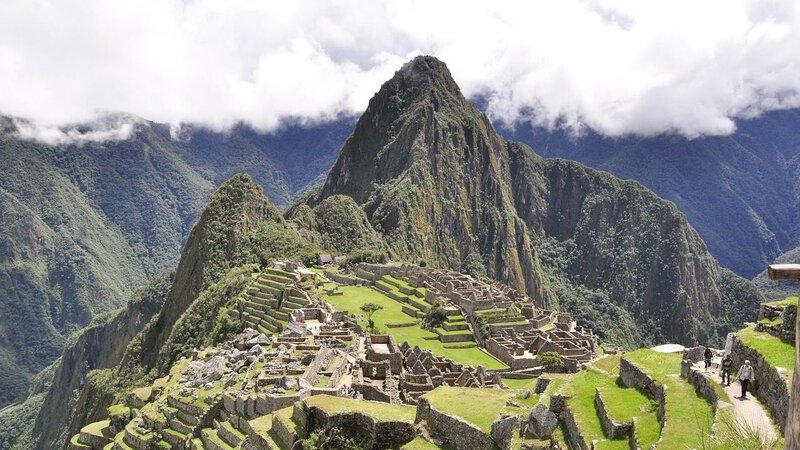
The Inca Empire is gone, but its bones remain visible in the landscape and in everyday life. Machu Picchu, the terraced mountain citadel above the Urubamba River in Peru, draws more than a million visitors a year — the most vivid single marker of where the Inca Empire stood and what it could build without metal tools, wheeled machinery, or mortar between its precisely fitted stones. Agricultural terraces carved into Andean hillsides still hold soil that would otherwise have washed away centuries ago. Hundreds of potato varieties first cultivated in these mountains remain foundational to global food supply today.
The Qhapaq Ñan road system was designated a UNESCO World Heritage Site in 2014, recognized across all six modern nations — Colombia, Ecuador, Peru, Bolivia, Chile, and Argentina — that the Inca Empire once united under a single authority. Freeze-drying technology, practiced by Andean peoples for thousands of years and refined under the Inca as a method of preserving food at high altitude, is the direct ancestor of freeze-dried products now found in camping supply stores and emergency preparedness kits worldwide.
And Quechua lives. In highland markets and urban neighborhoods from Cusco to Quito, the language the Inca spread as a tool of empire is still spoken, still sung, still argued over, still whispered to children at night. That persistence — linguistic, agricultural, architectural — is its own kind of answer to the question of where the Inca Empire was. It was here. Much of it still is.
Think again of that runner, sprinting a mountain pass at dawn, carrying the empire’s pulse in his lungs and his memory. The pass he ran is now a highway, or a hiking trail, or nothing but wind and grass. But the Andes he ran through are unchanged — the same savage, beautiful, improbable mountains that once formed the spine of an empire stretching 4,000 miles on human feet alone. No wheel. No horse. No written word. Just the mountains, the roads, and the people who refused to stop.

 English
 French
 Spanish
 Portuguese
 Deutsch
 Turkish
 Dutch
Dutch
 Italiano
 Russian
 Romaian
 Portuguese (Brazil)
 Greek
Greek