

Somewhere on a stone road carved into the Peruvian Andes, at roughly 4,000 metres above sea level, a young man is running. His lungs burn in the thin air. His feet know every irregularity in the fitted granite beneath them. Tucked against his chest is a quipu — a bundle of knotted cords carrying a message that will travel 2,400 kilometres in a matter of days, passed from runner to runner along a road system that shouldn’t exist, in an empire that by every geographical logic shouldn’t exist either.
The Mountain Range That Splits a Continent

To understand the Inca, you first have to stand in front of the Andes and feel genuinely humbled. The Andes Mountains run the entire length of South America’s western coast, a continuous chain of highland stretching over 9,000 kilometres from the Caribbean shores of Venezuela all the way to the wind-scoured tip of Patagonia. They are the world’s longest continental mountain range, a geological spine that dramatically divides South America into two utterly different worlds: the Pacific coast on one side, the Amazon basin on the other.
The scale is difficult to hold in the mind. The range crosses seven countries — Venezuela, Colombia, Ecuador, Peru, Bolivia, Chile, and Argentina — and within that corridor, it stacks radically different climates on top of one another like floors in a tower block. Within a single day’s walk, a traveller can pass from dense jungle through grassland and highland savanna into cold desert and up to permanent ice. Aconcagua, rising to 6,961 metres (22,838 feet) in Argentina, is the highest peak in the Western Hemisphere and the tallest mountain on Earth outside of Asia. It is not an outlier — it is merely the tallest member of a range whose logic is excess.
This geography is not merely backdrop. The Andes shaped every civilisation that ever grew within them, determining what people could eat, where they could live, how they moved, what they feared, and what they worshipped. For the Inca, the mountains were not an obstacle to be overcome. They were the entire point.
Before the Inca: Ancient Peoples Who Learned the Mountain’s Rules

Humans have been reading the Andes for a very long time. Archaeological evidence places people in the highlands at least 12,000 years ago, and in the millennia that followed, a succession of cultures quietly solved problems that no other civilisation on Earth had faced at quite this altitude.
The Chavín culture, flourishing between roughly 900 and 200 BCE, built ceremonial centres in the highlands and traded across altitude zones, leaving behind monumental stone architecture and a sophisticated iconographic tradition that influenced Andean art for centuries. Later, the Tiwanaku civilisation — centred on the shores of Lake Titicaca at over 3,800 metres — and the Wari Empire, both peaking between approximately 500 and 1000 CE, pioneered the administrative and agricultural techniques the Inca would eventually inherit and amplify. What all of these cultures understood was a truth the mountains enforced without compromise: survival at altitude required a fundamentally different kind of ingenuity.
The agricultural revolution that unfolded in the Andes is one of history’s most underappreciated stories. Andean peoples domesticated the potato — not one variety, but dozens, each tuned to different altitudes and frost conditions — along with quinoa, which thrives in cold, thin-aired conditions that would kill most crops. They domesticated the llama and alpaca, animals that could carry loads, provide wool, and yield meat at elevations where cattle cannot breathe reliably. And they invented the andenes: stone terraces carved into steep mountain slopes to capture soil, retain moisture, and create level agricultural land above 3,500 metres. These terraces were not simply farming infrastructure. They were the Andes rewritten in human hands.
Into this landscape, around 1438 CE, stepped a ruler named Pachacuti — whose name translates, with appropriate grandeur, as “World-Shaker.” From the highland city of Cusco, he launched a campaign of conquest that would, within a century, stitch all of this accumulated Andean knowledge into the largest empire the pre-Columbian Americas had ever seen.
Cusco: The Navel of the World at 3,400 Metres

Cusco sits at roughly 3,400 metres in a valley of the Peruvian Andes, and the Inca did not choose this location casually. They called it Qusqu — the navel of the world — and designed the city to function as a cosmic centre, with sacred sight lines aligned to mountain peaks, stars, and the movements of the sun. The city was not built despite its terrain; it was built to mirror it.
At the heart of Cusco stood the Coricancha, the Temple of the Sun, its walls once sheathed in gold plate that blazed at dawn like a second sunrise. From this temple radiated 41 invisible sacred lines called ceques, connecting more than 300 huacas — sacred sites — spread across the surrounding landscape. The vast majority of these sites were geographical features: mountain peaks, springs, caves, rock outcroppings. The Inca had made the mountain landscape itself into a living religious text, a map of the divine written in stone and water.
Their principal deities reflected this with remarkable literalness. Inti, the sun god, governed the cycles of warmth and cold that determined whether crops lived or died at altitude. Pachamama, the earth mother, embodied the soil and rock the Inca terraced, planted, and built upon. Worship, in the Inca world, was inseparable from practical survival. The mountains they called Apus were not symbols of deities — they were deities, living presences whose moods could bless a harvest or bury a village in ice.
The empire itself — Tawantinsuyu, “The Four Regions” — was defined entirely by Andean geography. Its four quarters radiated outward from Cusco along the natural corridors of the mountain range, following valleys, passes, and river systems as though the landscape had always intended to be an empire and was simply waiting for someone to notice.
The Inca Road Network: Engineering the Impossible

The central paradox of Inca civilisation is this: a culture without iron tools, wheels, or alphabetic writing built one of the most sophisticated road networks in human history across some of the most extreme terrain on Earth. The Andes presented engineering challenges that would test modern builders — and the Inca answered them with solutions that still inspire disbelief.
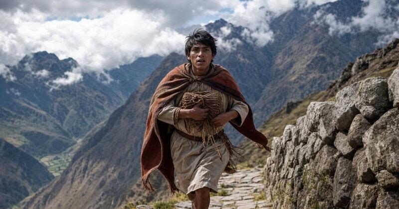
The Qhapaq Ñan, or Royal Road, extended approximately 40,000 kilometres across the empire, connecting the highlands from modern-day Colombia to central Chile. It was not a single road but an arterial system — a spine with ribs — and every kilometre had to negotiate the Andes’ vertical logic. Where terrain fell away into gorges, engineers wove suspension bridges from braided grass fibres, structures capable of bearing the weight of laden llamas and marching armies. Where cliffs blocked progress, stone staircases were cut directly into the rock face. Tunnels pierced ridgelines. Causeways crossed marshes. At precise intervals, tambos — way stations — provided food, equipment, and shelter for travellers, runners, and soldiers.
The runners themselves — the chasquis — were the empire’s nervous system. Trained from youth and stationed in relay pairs at each tambo, they could move information and small cargo across the entire length of the empire at speeds that astonished the Spanish when they arrived. Fresh fish from the Pacific coast reached Cusco while it was still edible. Military orders moved from the capital to distant frontiers in days. The mountains that made movement impossible for outsiders had become, through this infrastructure, the Inca’s express highway.
UNESCO recognised the Qhapaq Ñan as a World Heritage Site in 2014, and surviving sections remain walkable today across Peru, Ecuador, Bolivia, Argentina, Colombia, and Chile — stone paths laid by hands that have been dust for five centuries, still carrying travellers through the clouds.
Living at the Roof of the World: Adaptation, Science, and Survival

Modern science has confirmed what Andean communities have always known in practice: living at extreme altitude changes you, biologically. People whose ancestors inhabited the high Andes for generations carry genetic adaptations that alter how their blood processes oxygen, enabling them to function effectively at elevations where lowland populations struggle and can suffer acute altitude sickness. The altiplano — the high plateau averaging around 3,750 metres that stretches across Peru and Bolivia — is not merely a place where humans endure. For adapted populations, it is home in the deepest possible sense.
The Inca understood the physics of altitude even without the vocabulary of modern science, and they turned those conditions to extraordinary advantage. Chuño — freeze-dried potato — is perhaps the most elegant example. By leaving potatoes outside on cold highland nights and drying them under the intense thin-air sun, Andean communities created a food that was light, portable, and storable for years without spoiling. Armies marched on chuño. Famine was held at bay by chuño. It was a technology born entirely from the specific conditions of the Andes: cold nights, dry air, brilliant sun, and altitude.
More impressive still was the Inca’s mastery of vertical ecology. By controlling territory across multiple altitude zones simultaneously — coast, valley, highland, altiplano — the empire could hedge its agricultural bets with remarkable sophistication. A drought at one elevation rarely struck all elevations at once. A frost that killed crops at 3,500 metres might leave the lower valleys untouched. By holding all these zones within a single political system and moving surplus goods along the Qhapaq Ñan between them, the Inca created a food security network more resilient than almost any contemporary civilisation elsewhere in the world.
And then there were the highest peaks themselves. The Apus were not merely worshipped from a distance. At summits above 6,700 metres — where the air contains barely half the oxygen available at sea level — archaeologists have recovered remarkably well-preserved remains from capacocha ceremonies: sacred rituals in which the Inca brought offerings to the mountain gods at extraordinary altitude. The mountains received these in silence, as they always had, and held them in their ice for centuries until modern researchers climbed up to find them.
The Mountains Remain: Legacy, Loss, and What the Andes Still Hold

When Francisco Pizarro and his conquistadors arrived in 1532, they brought steel, horses, firearms, and diseases against which the Inca had no immunity. The political structure of the empire collapsed with terrible speed. But the geography did not. The Andes — which had built the empire — sheltered its remnants for decades. At Vilcabamba, deep in the mountains northwest of Cusco, Inca resistance held out for nearly forty years after the capital fell, the mountains doing what they had always done: making conquest expensive, slow, and exhausting for anyone who didn’t know their logic.
The mountains also hid things the Spanish never found. The Andes contain hundreds of archaeological sites that remain only partially understood. Machu Picchu — constructed at 2,430 metres on a narrow ridge above the Urubamba River, surrounded by cloud forest and sheer drops — was never discovered by the Spanish. It remained unknown to the outside world until 1911, a city of precisely fitted stone and agricultural terraces balanced on the edge of the sky. It is the most famous Inca site, but it is far from alone. LiDAR surveys in recent years have revealed hidden structures beneath the cloud forest canopy across the broader Andean region, sites that have never been excavated, histories that haven’t yet been told.
Today, the Andes stand at a crossroads of ancient history and urgent modernity. The glaciers that fed the springs and rivers watering Inca terraces for centuries are retreating at accelerating speed under a warming climate. The highland communities that have farmed those same terraced slopes across generations — inheritors of an agricultural tradition stretching back long before the Inca themselves — face water insecurity that their ancestors, for all their ingenuity, could not have anticipated.
The deepest truth about the Inca and the Andes is this: the Inca did not conquer their landscape. They listened to it. They learned its languages — of altitude and frost, of thin air and vertical distance — and they answered in stone roads, grass bridges, freeze-dried food, and sacred lines connecting springs to stars. The mountains were never the backdrop to their story. The mountains were the author. Understanding that is the beginning of understanding one of the most remarkable civilisations the world has ever produced — and of understanding what we stand to lose if the ice that remembers them continues to disappear.