

The grass looks like nothing. Just another sweep of Wiltshire chalk downland, pale green in the early light, utterly unremarkable to any eye that has not learned to mistrust the surface of things. Then the researcher pushes the ground-penetrating radar cart forward another metre, glances at the screen — and the earth gives up a secret it has kept for five thousand years.
The Field That Looked Empty

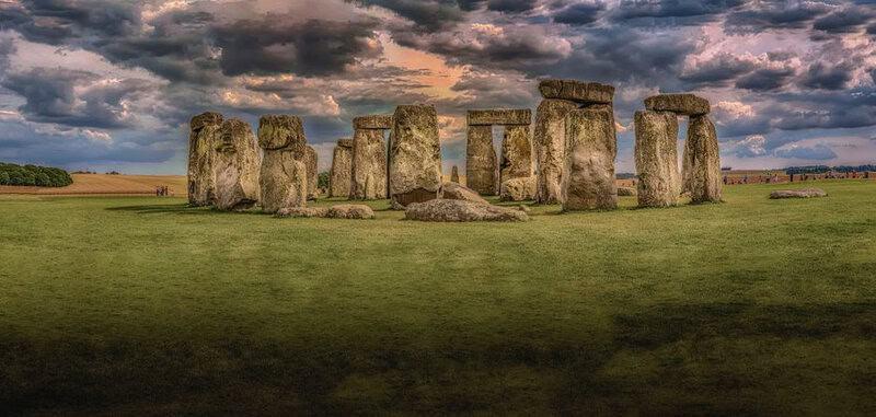
For generations, Stonehenge dominated every conversation about itself. The great sarsen trilithons, the bluestone horseshoe, the heel stone catching the midsummer sunrise — these were the story, and the rolling chalk plain around them was understood to be, more or less, a backdrop. A few known burial mounds, a processional avenue, the circular earthwork of Durrington Walls a couple of miles to the north-east: scholars had catalogued these and felt, if not satisfied, at least oriented. They thought they knew the neighbourhood.
They were reading only the top line of a much older text.
What new geophysical surveys are revealing — through magnetometry, ground-penetrating radar, and years of painstaking data analysis — is that the landscape surrounding Stonehenge is not a backdrop at all. It is the story. Dozens of previously unknown prehistoric monuments lie buried beneath ordinary-looking fields: pit circles, timber enclosures, massive subsurface pits, processional routes, shrines. A prehistoric ceremonial world of extraordinary density and complexity, invisible to every eye until now.
And then there is the stone. One large monolith associated with Stonehenge has been traced, by its geological signature, to an origin in north-east Scotland. Researchers believe it may have travelled southward on glacial ice, crossing what is now a drowned territory called Doggerland, before eventually reaching its current location. The mechanism by which it completed that journey had, until recently, remained genuinely unknown. That detail alone suggests this story goes deeper, and further, than anyone had imagined.
What We Thought We Knew

The familiar picture of Stonehenge is so embedded in the cultural imagination that it can be difficult to see it clearly. The monument was built in phases over many centuries, beginning around 3000 BCE in the Neolithic period and continuing into the early Bronze Age. Enormous sarsen stones — some weighing more than twenty-five tonnes — were hauled from Marlborough Downs, roughly twenty-five miles away. The smaller bluestones came from the Preseli Hills in Wales, more than 150 miles distant. Whatever ritual purpose the structure served, the organisational ambition behind it was staggering.
Yet for much of the history of serious archaeology, the wider Stonehenge landscape was treated as largely understood and secondary. Attention fixed on the monument itself: its alignments, its construction sequences, its probable function as a place of ancestor veneration or solar ceremony. The surrounding Salisbury Plain was assumed to be a relatively sparse backdrop — important, but legible. A canvas on which the main subject had already been identified.
The Stonehenge Hidden Landscapes Project changed that assumption systematically and permanently. Launched as a major collaborative research effort, the project deployed an arsenal of non-invasive survey technologies — ground-penetrating radar, magnetometry, earth resistance survey, and more — across the Stonehenge World Heritage Site. The goal was not to find one lost monument but to build a complete subsurface map of the entire sacred landscape, to understand Stonehenge not as an isolated wonder but as part of something far larger. What the surveys returned was beyond anything the project’s architects had publicly anticipated.
The Technology That Sees Through Time

Ground-penetrating radar works by firing pulses of electromagnetic energy into the ground and measuring the time it takes for those pulses to bounce back from buried features — ditches, pits, stone settings, compacted floors, decayed timber posts. Different materials return different signals. The instrument records these reflections as cross-sectional slices of the earth, and software stitches thousands of those slices together into three-dimensional maps of what lies below. No shovel required. No site disturbed.
The scale of the Hidden Landscapes Project surveys was itself remarkable. Teams moved across the landscape in systematic grids, instruments towed behind all-terrain vehicles, covering ground at a pace that earlier generations of archaeologists — working trench by careful trench — could never have matched. The data generated ran to terabytes. Processing it, interpreting it, reconciling it with existing knowledge of the site: this was work that stretched across years and demanded both computational power and hard-won human expertise.
Because the technology has real limits. Ground-penetrating radar shows shape and depth; it does not identify. A circular anomaly at a certain depth might be a Bronze Age barrow, a natural geological feature, or something without clear precedent. The screen gives you an outline; only an archaeologist who knows the period, the context, and the conventions of monument-building can tell you what that outline means. The instrument sees through time. The interpretation is still human.
And yet, as the data accumulated and the interpretations compounded, something extraordinary emerged. Dozens of previously unknown monuments resolved themselves from the noise. A prehistoric ceremonial landscape of astonishing complexity — buried, intact, and waiting — came into focus beneath the grass.
The Hidden Monuments: A Prehistoric Landscape of Ritual

The individual discoveries form a catalogue of revelations. Near Durrington Walls, where Neolithic communities are believed to have gathered in large numbers, surveyors identified a row of massive subsurface pits — some reportedly more than ten metres across — arranged within a vast enclosure that dwarfs anything visible on the surface. This buried structure suggests an organised, large-scale ritual landscape with few obvious parallels in the known archaeology of the site.
Elsewhere across the survey zone, buried shrines emerged. Processional routes appeared, connecting monuments to each other and to the movements of sun and moon in patterns that prehistorians are still working to decode. Timber enclosures — long since rotted, their posts now nothing but dark stains in the soil — outlined spaces where people once gathered for purposes we can only infer. Pit circles, some of them predating the standing stones themselves, quietly complicated the accepted timeline of organised monumental activity at the site.
That last point deserves emphasis. Some of the buried structures identified by the surveys appear to be older than the Stonehenge we know. The assumption that monumental ambition at this location began with the famous trilithons — or even with the first earthwork enclosure around 3000 BCE — is no longer secure. People were doing something organised and intentional here earlier than that. Stonehenge, in the new picture, is not the beginning of the story. It may not even be the climax.
The human implication of all this density is striking. These were not empty ritual sites, visited once in a generation for a solemn ceremony and then abandoned to the elements. Evidence of feasting recovered from the wider landscape — animal bones, signs of large-scale communal meals — points to gathered communities, seasonal celebrations, sustained social life. The Stonehenge landscape was not a monument park. It was something closer to a living ceremonial centre, used and reused and added to across centuries: a place where the dead were honoured and the living came together in numbers that would have made it one of the most significant gathering points in prehistoric Britain.
The Travelling Stone: Across a Lost World

Set against this backdrop of local revelation, the story of the travelling monolith takes on a different kind of weight.
Researchers studying the geological signature of a large stone associated with Stonehenge have traced its origin to the Orcadian Basin — the region around north-east Scotland. This is not a distance anyone previously associated with the transport of material to Stonehenge. The bluestones from Wales were already considered an extraordinary logistical achievement. North-east Scotland belongs to a different order of distance entirely.
The explanation researchers have proposed involves Doggerland: the vast, low-lying landmass that once connected Britain to mainland Europe before rising sea levels drowned it. In this model, the stone may have travelled via glacier southward from its Scottish origin, eventually coming to rest somewhere in what is now the bed of the North Sea. When Neolithic people eventually encountered the stone, perhaps on Doggerland’s remnant shores, they recognised something worth moving — and moved it.
It is important to be honest about the limits of this evidence. The glacier-then-human-transport model is the most coherent explanation researchers have yet proposed for how a stone from north-east Scotland arrived in Wiltshire. It is not an established, fully evidenced fact at every stage of the journey. What the research establishes with confidence is the geological origin; the proposed route remains the best current inference from that origin, not a settled conclusion.
But even as inference, it is extraordinary. It means that Neolithic Britons were operating within a geographic world — and almost certainly a cultural and exchange world — far larger than previously imagined. Moving an object of that size across that distance with evident intention is not the behaviour of isolated communities scraping subsistence from the chalk. It is organised, purposeful, long-range ambition encoded in stone.
Rewriting Prehistoric Britain

Taken together, the findings of the Stonehenge Hidden Landscapes Project and the research into the travelling monolith point toward a single, transformative conclusion: we have been underestimating the people who built this landscape for a very long time.
The Neolithic and early Bronze Age communities responsible for Stonehenge and its surroundings were capable of landscape-scale planning that unfolded across multiple human generations. They managed long-distance logistics that would challenge well-organised societies in any era. They encoded knowledge of solar and lunar cycles into structures that have outlasted every empire that came after them. They were not anonymous primitives. They were people who grieved and celebrated, who navigated across vast distances and built for permanence with a ferocious, patient intelligence.
The Stonehenge landscape finds echoes in parallel revelations elsewhere. At Avebury, just seventeen miles north, surveys have similarly expanded the known ceremonial landscape beyond its visible monuments. In Orkney, the extraordinary concentration of Neolithic sites — Skara Brae, the Ring of Brodgar, the Ness of Brodgar — speaks to a northern tradition of monumental community life that may be directly connected to the very stone that ended its journey on Salisbury Plain. In Ireland’s Boyne Valley, passage tombs aligned to the winter solstice sunrise suggest a shared cosmological grammar stretching across the British Isles. These were not isolated communities. They were nodes in a network.
The work of the Hidden Landscapes Project is not finished. Survey data continues to be processed and interpreted. Archaeologists working on the project openly acknowledge that future field seasons could change the picture again — that there are anomalies in the data whose meaning is not yet clear, structures whose age and purpose remain to be determined. The map of the invisible is still being drawn.
What Lies Beneath: The Future of the Forgotten Land
Return, at the end, to that field at dawn. The researcher. The radar cart. The grass that looks like nothing.
Beneath that ordinary surface, in the cool dark below the chalk, there are walls and pits and post-holes from thousands of years ago, preserved by the very soil that hides them. There are the outlines of ceremonies we have no words for, the traces of gatherings whose participants have been dust for a hundred generations. There are structures that no living person has yet identified, waiting for an instrument sensitive enough to find them.
One of the most remarkable things about non-invasive archaeology is what it does not do. It does not dig. It does not disturb. The discoveries made by ground-penetrating radar and magnetometry remain where they were found — intact, protected, available to future researchers wielding technologies we have not yet invented. We are learning, for the first time, to read the past without consuming it.
And there is so much past left to read. Experts involved in the Hidden Landscapes Project are candid about the fraction of the wider Stonehenge landscape that has so far been surveyed. The most significant finds — the structure that finally clarifies the alignments, the buried complex that reorders the entire sequence — may still lie out there, under a field that looks like nothing, waiting for the screen to come alive.
Stonehenge was never just a monument. It was — and the radar is proving it, one ghostly outline at a time — the centre of a world.