


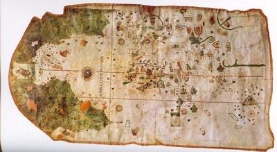
This scrappy piece of parchment marks a world-changing moment in human history. Completed around 1500 CE – or so we think – it is the first known map to depict Europe, Asia, and Africa alongside the coasts of the Americas.
The rest of this article is behind a paywall. Please sign in or subscribe to access the full content. The first Europeans to set foot in North America were Norse Vikings, who sailed between Greenland and present-day Canada around 1000 CE. However, it wasn’t until the late 15th century that systematic European exploration and colonization of the continent began, with the famous/infamous voyages of Christopher Columbus, who made landfall in 1492. Second-in-command on this journey was Juan de la Cosa, the owner of Columbus’s flagship Santa María, who had a penchant for map-making. He is credited with creating the first European map of the Americas – and perhaps the earliest map to depict the Americas at all. While pre-Columbian cultures had their own ways of representing geography and territories, they did not create maps in the way modern audiences tend to imagine. A close-up of Juan de la Cosa's 1500 world map showing the bit that depicts the Americas. A legend on the map reads, in Spanish, “Juan de la Cosa made this in the port of Santa Maria in the year 1500,” Puerto de Santa Maria being a small port in the province of Cádiz, Andalusia. It would be highly unlikely that a map of this kind was reproduced en masse; at a time when the so-called “New World” was being hotly contested over, the knowledge it held could wield huge political power. His map shows the Americas as the edge of a large landmass, leading to a mysterious domain beyond, the extent of which the map doesn't even attempt to depict. As so little was known to Europeans about this uncharted territory, the map of the Americas is largely devoid of complex features, aside from a few lines hinting at rivers or territories. The land, however, is overwhelmingly green, offering a glimpse of the impression the first European explorers might have had upon arriving. The depictions of Europe, Asia, and Africa appear to have been based on other existing maps and knowledge from the time, which the Spanish and Portuguese were particularly sharp at gathering and using. Comparisons with 21st-century maps show that the representation of the Americas’ coastline is far from accurate by modern scientific standards. Although crude, it is possible to make out a rough outline of North America, the Caribbean islands, and the northern part of South America. Comparison of coastal outlines on maps of Juan de la Cosa (black line) and Martin Behaim (light dotted line) with the true coastline. However, for a map created centuries before satellites, GPS, and modern surveying techniques, it's pretty impressive. Crucially, it hints that the Americas were not part of Asia, as Columbus and many of his crew had believed. That said, it is notable that the map does not depict the Americas as a fully separate landmass; it is possible that the unseen western side could wrap around the Earth and connect to Asia. We simply don’t know, and it seems de la Cosa wasn’t totally sure either. Despite the map's significance, it was essentially lost for centuries. Outside the inner circles of European monarchs and their trusty explorers, the map was unknown to the wider world until 1832, when it was bought by Charles Walckenaer, a French scientist, from a junk shop dealer in Paris. How did it end up here? The most likely explanation is that it was taken out of the Secret Archives at the Vatican by Napoleon when he seized them in 1810 and moved them over to Paris. This isn’t the only strange story surrounding Juan de la Cosa’s map. The map is so ahead of its time that some scholars have seriously argued it couldn’t possibly have been made in 1500, just eight years after the first voyage of Columbus. They propose it's actually a medley of other maps, made as late as 1529 by European draughtsmen, roughly based on the exploits of de la Cosa. Perhaps, it's been suggested, that another man named Juan de la Cosa was involved, hence the confusion. If the map of de la Cosa really was created later than 1500, perhaps the true earliest map of “America” is Martin Waldseemüller's world map. Created in 1507, it is the first map to depict the Western Hemisphere as its own continental landmass, surrounded by sea and not connected to Asia. The Waldseemüller map. Image credit: Martin Waldseemüller via Wikimedia Commons (Public Domain) This beautiful cartographic illustration, which looks straight out of a pirate's tale, is the first map to use the word “America,” named after Amerigo Vespucci, an Italian explorer who took part in two early voyages to the “New World” around the turn of the 16th century. So yes, while Italians cannot claim to have “discovered” the Americas – Indigenous peoples had been thriving there for many thousands of years before Columbus was born – they can claim credit for its modern name.
 and Martin Behaim (light dotted line) with the true coastline.")
The Strange Stories Of Juan de la Cosa's Map
Waldseemüller Map: The First Map To Call It "America"
