

Somewhere in the jungle of what is now southern Mexico, a civilization quietly took root more than three thousand years ago — and then spread, endured, and transformed across a swath of the Americas so vast it would astonish most people who picture the Maya as a single, compact culture. Reading a Maya civilization map carefully reveals not just where these people lived, but why their landscape made them who they were.
A civilization sprawling across five modern nations and 500,000 square kilometres

When you unfold a map of ancient Maya territory, the first thing that strikes you is sheer scale. Maya lands covered what is today southeastern Mexico, the entirety of Guatemala and Belize, and the western edges of Honduras and El Salvador — a footprint exceeding 500,000 square kilometres, roughly the size of Spain. That single fact dismantles any notion of the Maya as a small, regional phenomenon tucked away in one corner of the ancient world.
Perhaps equally striking is the political reality that no single modern country can claim the Maya as exclusively its own. Their civilization predates every border on the contemporary map, slicing across five sovereign nations whose governments now cooperate — sometimes awkwardly — to manage a shared archaeological inheritance. Asking where the Maya lived is, in the end, a question that belongs to half a continent.
Dense rainforest, not open plains, was the cradle of the civilization

The earliest roots of Maya culture did not emerge on fertile river floodplains or open savannas, as with many other early civilizations. Instead, they took hold in the dense jungle terrain of Mesoamerica — one of the most demanding environments on earth. Thick forest canopy, seasonal flooding, and thin limestone soils forced early Maya engineers to devise sophisticated systems of water management, raised-field agriculture, and land modification simply to feed their communities. Those hard-won innovations would later define the grandeur of their cities.
The same jungle that forged Maya ingenuity also concealed it. For centuries after European contact, the rainforest swallowed temples whole, preserving ruins while hiding their existence from outside eyes. Accurate mapping of the civilization’s true extent remained an unfinished project well into the modern era, making what we now call the Maya civilization map less a historical document than an ongoing scientific discovery.
The geographic range ran from the Yucatán Peninsula to El Salvador’s western edge

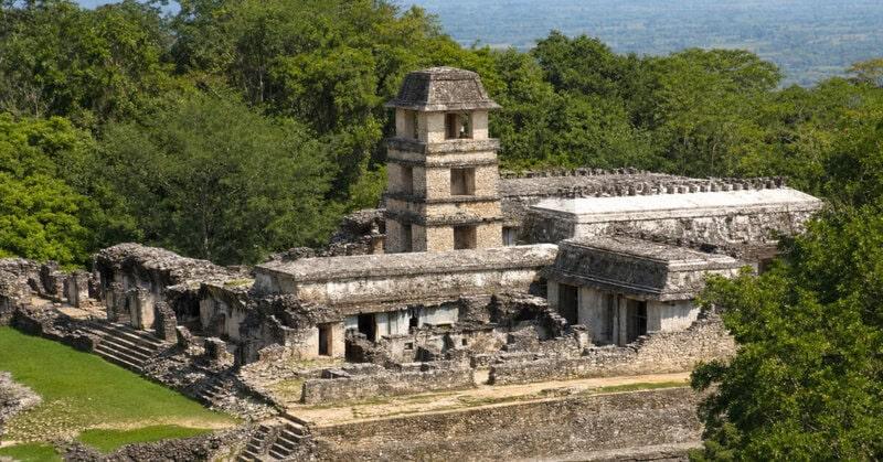
Core Maya zones took in an extraordinary range of landscapes: the flat limestone shelf of the Yucatán Peninsula, the humid lowland forests of Tabasco and the Petén, the cool volcanic highlands of Guatemala, the river valleys of Belize, and a corridor of western Honduras. To speak of “Maya civilization geography” as though it describes one kind of place is to miss the point entirely — the Maya world was always a mosaic of radically different environments, each with its own rhythms of rain, soil, and stone. Scholars studying the Maya consistently emphasize this ecological diversity as central to understanding the culture.
Each ecological zone generated distinct city types, trade specializations, and political cultures. Highland cities quarried volcanic obsidian and traded it down to lowland centers hungry for that razor-sharp material. Coastal settlements harvested salt and marine goods that flowed inland along well-worn trade routes. When you trace the full ancient Maya civilization across its geographic breadth, you are reading the story of dozens of different environments learning to talk to one another. The range and variety of Maya urban forms is explored in detail by Maya archaeologists studying cities and architecture across the region.
A 3,000-year-old cosmic map carved into bedrock — the Maya were mapping the universe before their cities peaked

Beneath the surface of Mexico’s oldest known Maya site, archaeologists uncovered something remarkable: a monumental cosmogram, a carved representation of the cosmos, dating to roughly 3,000 years ago. That places it centuries before the Classic Maya period that most people picture when they think of towering pyramids and hieroglyphic inscriptions. The discovery, reported in Scientific American, suggested that cartographic and spatial thinking was not a late refinement of Maya culture but one of its foundational impulses.
The site itself proved unexpectedly large in scale, challenging long-held assumptions that early Maya settlements were small and loosely organized. Instead, the evidence pointed to a community capable of monumental planning and cosmological ambition from very early on. As Smithsonian Magazine reported, the find reframes how scholars understand the origins of Maya civilization. Further coverage in Popular Mechanics and BBC Science Focus highlighted that the cosmogram suggests sophisticated spatial reasoning was present at the very dawn of Maya society, not a product of its later flowering.
The last independent Maya city wasn’t conquered until 1697 — nearly 2,700 years of continuous presence

Most histories of the ancient world treat civilizations as things safely sealed in the past, separated from us by comfortable millennia. The Maya refuse that treatment. Tayasal, situated on an island in Lake Petén Itzá in present-day Guatemala, was the final independent Maya political stronghold — and Spanish forces did not subdue it until 1697. That year places the end of sovereign Maya rule within the lifetime of Isaac Newton, who had published his laws of motion just a decade earlier. The “ancient” Maya were still politically alive when the modern scientific revolution was underway.
On any timeline map of the Maya world, that end date sits startlingly close to the present. From the earliest evidence of Maya culture to the fall of Tayasal spans roughly 2,700 years — a continuous human presence in the same geographic territory that dwarfs the entire recorded history of most European nations. The full sweep of Maya civilization history is, by any measure, one of the longest stories in the human record.
The Maya’s calendar precision was a direct product of their long, stable occupation of one mapped region

The Maya developed one of the most accurate calendar systems in human history, an achievement that has fascinated astronomers and historians alike for generations. A key factor, scholars argue, was geographic stability. Because Maya cities were built from stone and occupied across centuries, observers could construct permanent observatories and accumulate sky records spanning hundreds of years. That kind of deep, multigenerational data collection was simply not available to cultures that relocated frequently.
In this sense, Maya civilization geography was not merely the backdrop to intellectual achievement; it was the silent engine driving it. Fixed cities meant fixed observation points. Fixed observation points meant cumulative knowledge. And cumulative knowledge, refined across centuries of occupation in one mapped region, produced a calendar capable of tracking the movements of Venus with remarkable precision. Where the Maya lived turns out to explain, in no small part, how they achieved what they did intellectually.
GIS and LiDAR technology are actively redrawing the Maya civilization map today
Modern technology has become an unlikely hero of Maya cartography. ESRI, the geographic information systems company behind much of the world’s mapping software, undertook a dedicated project titled “Putting the Maya Civilization Back on the Map” — a name that doubles as an admission of how incomplete our geographic picture of this civilization has been. Using GIS platforms, researchers layered terrain data, LiDAR aerial scans, and archaeological records to reveal city networks and settlement patterns that centuries of ground-level survey had missed entirely.
LiDAR, which fires laser pulses from aircraft to measure ground surfaces hidden beneath jungle canopy, has proven particularly transformative. In recent years it has exposed vast interconnected urban systems in Guatemala and Belize that were invisible to earlier explorers walking beneath the trees. The ESRI project sits within that broader revolution — a recognition that reading the full Maya civilization map requires tools that the Maya’s own era could never have imagined, applied to a landscape their engineers shaped with extraordinary sophistication. For a broader visual introduction to the Maya world and its geography, the documentary overview available on YouTube provides useful context alongside these technical advances.
The Maya never formed a single empire — their map was always a mosaic of rival city-states
One of the most persistent misunderstandings about the Maya is embedded in the phrase “Maya empire” — as though a single capital once stretched its authority across all 500,000 square kilometres of the Maya world, the way Rome or the Aztec Triple Alliance did within their spheres. No such capital ever existed. The Maya map was always a patchwork of independent and semi-independent polities: city-states that traded, intermarried, warred, and occasionally dominated one another, but never fused into a single unified state with one ruler and one administrative centre. Historians of the Maya consistently emphasize this decentralized political geography as fundamental to understanding the culture.
That decentralization proved to be a profound survival advantage. When any single Maya city collapsed — whether through drought, warfare, or political breakdown — its neighbors absorbed refugees, continued trading, and kept the broader culture alive. The so-called “collapse” of the Classic Maya, so often narrated as a civilization-wide death, was in truth a regional crisis within a much larger, more resilient geographic mosaic. The map, read honestly, tells you why the Maya lasted as long as they did.
What the map ultimately tells us
Taken together, these facts reveal that the Maya civilization map is not merely a record of where people happened to settle. It is the key to understanding how they built, thought, traded, endured, and ultimately outlasted almost every other civilization of the ancient Americas across nearly three thousand years of continuous history. Geography was never just the stage on which Maya civilization performed — it was a co-author of everything the Maya became.