

Landslides are – well, the clue is rather in the name: it’s “defined as the movement of a mass of rock, debris, or earth down a slope,” explains the United States Geological Survey, or USGS.
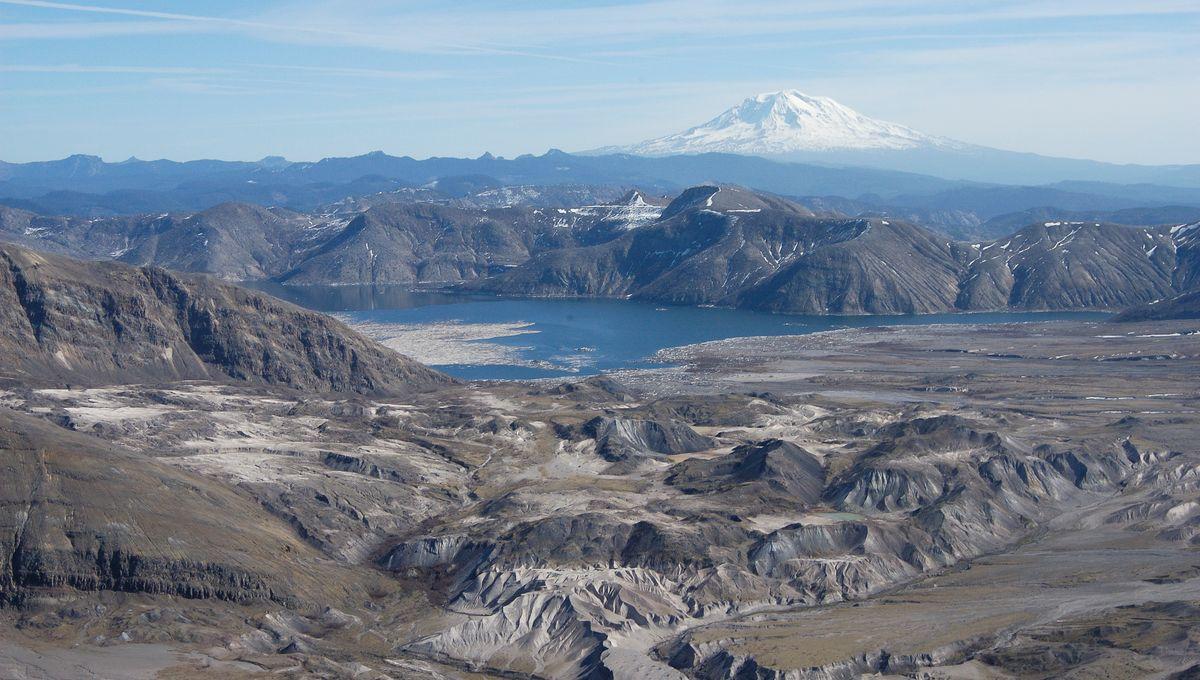
The rest of this article is behind a paywall. Please sign in or subscribe to access the full content. They’re a type of what’s known as “mass wasting” – a very general term referring to any movement of rock or soil down slopes – and they can happen just about anywhere, including off-world. “A recent […] image taken by the Mars Reconnaissance Orbiter (MRO) […] showed relatively fresh landslides in a crater near Nili Fossae,” pointed out Universe Today’s Matt Williams back in 2021. “This area is part of the Syrtis Major region and is located just north of the Jezero Crater.” But whether out there or down here, landslides have the potential to be massive and devastating – and there’s one in the record books that surpassed all others before or since. And you’ve probably heard of it. Landslides are caused by pretty basic physical principles: essentially, they’re the result of an imbalance between gravity and friction. As the British Geological Survey elegantly puts it: “When the force of gravity acting on a slope exceeds the resisting forces of a slope, the slope will fail and a landslide occurs.” Sounds simple, right? Perhaps too simple, in fact – because, of course, something has to happen for the status quo to change. And when it comes to landslides, it turns out there’s quite a lot of possibilities, often hitting at the same time: “Almost every landslide has multiple causes,” confirms the USGS, “include[ing] factors that increase the effects of down-slope forces and factors that contribute to low or reduced strength.” That can mean things like heavy rainfall or an upswell of groundwater in the region – the added water increases the weight of the slipping material, lowers its strength, and reduces the friction, all of which makes it easier for the whole lot to come toppling down. It might be that the angle of the slope has changed, likely through erosion processes, until eventually it becomes too steep to hold itself up. Weird weather patterns can make the land slide – freeze-thaw cycles, for example, can reduce the cohesion, or “stickiness” of the earth and rock particles. And of course, there’s any number of human actions that make them more likely, from the obvious – mining, urban development, that kind of thing – to the nominally well-intentioned – clearing up “weeds” from an area, for example, can actually take out much of the material binding the earth together, leaving it granular and fragile. But even though they can occur anywhere, there are some places where all these circumstances are much more likely to come about – and so, for the biggest landslide in the world, we need to focus our search to a very particular type of setting. Landslides don’t have to be particularly destructive – but when they turn up as the result of other major geological events like earthquakes or volcanic activity, things can get majorly gnarly. “Landslides are common on volcanic cones because they are tall, steep, and weakened by the rise and eruption of molten rock,” points out the USGS. That’s for multiple, interwoven factors: “Magma releases volcanic gases that partially dissolve in groundwater, resulting in a hot acidic hydrothermal system that weakens rock by altering minerals to clay,” they explain, while “the mass of thousands of layers lava and loose fragmented rock debris can lead to fault zones that move frequently.” The power of the volcano-induced landslide is such that it could transform into a lahar – a violent, fast-moving flow of mud and debris, more like wet cement than rocky substrate, that can cover hundreds of kilometers of the landscape in a matter of a few hours. In a somewhat ironic twist, the landslide can even trigger further volcanic activity: “By removing a large part of a volcano's cone, a landslide may abruptly decrease pressure on the shallow magmatic and hydrothermal systems,” points out the USGS, “which can generate explosions ranging from a small steam explosion to large steam- and magma-driven directed blasts.” All of which brings us to… The biggest landslide in recorded history saw the confluence of all these factors: “a magnitude-5+ earthquake was accompanied by a debris avalanche, which in turn unloaded the confining pressure at the top of the volcano by removing the cryptodome,” records the USGS. “This abrupt pressure release allowed hot water in the system to flash to steam, which expanded explosively, initiating a hydrothermal blast directed laterally through the landslide scar.” Then, “because the upper portion of the volcano was removed, the pressure decreased on the system of magma beneath the volcano,” it explains. “A wave of decreasing pressure down the volcanic conduit to the subsurface magma reservoir, which then began to rise, form bubbles (degas), and erupt explosively, driving a 9-hour long Plinian eruption.” The crazy thing? This all happened not just within recorded history, but, for many of us, within living memory – and not even all that far from home. Why? Because the biggest landslide in history… happened at Mount St Helens, in Washington State, just 45 years ago. It was, to put it bluntly, a doozy. “The giant landslide at Mount St. Helens in 1980 had an effect like pulling a cork off a bottle of severely shaken soda,” explains the National Oceanic and Atmospheric Administration (NOAA). “Once the side of the mountain was removed, the volcanic gases exploded out of the side of the volcano producing a lateral blast […] traveling at speeds of up to 1,072 km/hr (670 mi/hr).” The blast took out everything in its path, killing dozens of people by asphyxiation and leaving the surrounding area “as barren as the moon,” says NOAA. Mud and volcanic debris poured down the side of the mountain at speeds that would be illegal on almost any highway; the landslide averaged 46 meters (150 feet) deep, and in some places, it was four times that. It “had a volume of 2.5 km3 (0.6 mi3), reached speeds of 50-80 m/s (100-180 mi/hr), and surged up and over a 400-m-tall (1300 ft) ridge located about 5 km (3 mi) from the volcano,” the USGS notes. For comparison, that’s about 1,000 Great Pyramids of Gizas-worth of rocky, muddy flow, rushing down towards the local populations at speeds that would strain many family cars. It took out hundreds of houses, dozens of bridges and railways, and an amount of highway that could take you two-thirds of the way through the entire Grand Canyon. No wonder it made the history books. And the craziest part? The effects can still be seen today. “The 1980 eruption sent immense amounts of mud, water, and debris downstream, overtopping banks and flooding low-lying valleys. Sediment clogged channels in the Toutle, Cowlitz, and, eventually, Columbia Rivers,” explains the USGS. “There was so much new sediment in the Columbia River that the riverbed rose by nearly 30 feet, halting ship traffic and severely impacting the local economy.” “Today, those rivers continue to transport sediment downstream at rates tens of times greater than before the eruption,” they add. “This enormous amount of extra sediment continues to pose challenges for flood protection and fisheries today. The lesson [is] clear: eruptions change river systems even decades later.”The causes of landslides
The other kind of volcanic activity
The biggest landslide on Earth